History
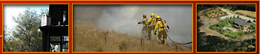
During the 2000 fire season wildfires burned millions of acres throughout
the United States. These fires dramatically illustrated the threat to human lives
and development. Under Executive Order, the National
Fire Plan was created as a cooperative, long-term effort of the USDA
Forest Service, Department
of the Interior, and the National
Association of State Foresters, to protect communities and restore ecological
health on Federal lands.
A major component of the National Fire Plan was funding for projects designed
to reduce fire risks to people and their property. A fundamental step in realizing
this goal was the identification of areas that are at high risk of damage from
wildfire. Federal fire managers authorized State Foresters to determine which
communities were under significant risk from wildland fire on Federal lands.
The CAL FIRE undertook the task of generating the state's
list of communities at risk. With California's extensive Wildland-Urban Interface
situation the list of communities extends beyond just those on Federal lands.
Three main factors were used to determine wildland fire threat to Wildland-Urban
Interface areas of California.
- Ranking Fuel Hazards = ranking vegetation types by their
potential fire behavior during a wildfire.
- Assessing the Probability of Fire = the annual likelihood
that a large damaging wildfire would occur in a particular vegetation type.
- Defining Areas of Suitable Housing Density that Would Create Wildland-Urban
Interface Fire Protection Strategy Situations = areas of intermingled
wildland fuels and urban environments that are in the vicinity of fire threats.
The Communities at Risk List includes a total of 1,289 communities. Of
those, 843 are adjacent to federal lands (USDA Forest Service, Bureau of Land
Management, Department of Defense, etc.) and are indicated as such with a checkmark in
the Federal Threat column. The Hazard Level Code included on the list designates
a community's fire threat level with 3 indicating the highest threat.
Some of our files require that you have Adobe Acrobat Reader
installed on your system. If you do not currently have Acrobat, or are not sure
if you have it installed, you can download
it directly from Adobe.
Return To Top
|